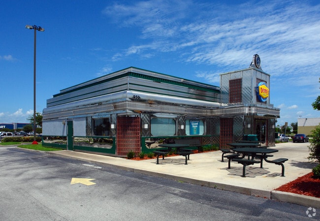
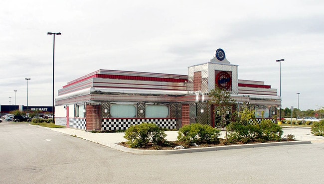
Property Record
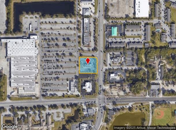
950 N Wickham Rd, Melbourne, FL 32935

NEARBY LISTINGS FOR SALE OR LEASE
Property Detail
950 N Wickham Rd
Palm Bay-Melbourne-Titusville, FL
A Plat Of The Wal-Mart At Melbourne
27-36-24-01-00000.0-0004.00
A PLAT OF THE WAL-MART AT MELBOURNE LOT 4
Restaurantdrivein
Brevard
X
Florida
12009C0581G
4
2024
0.93 AC
2025
Brevard County
064602
Orlando
1,955 SF
DEMOGRAPHICS near 950 N Wickham Rd
1 Mile
3 Mile
5 Mile
2024 Total Population
8,529
51,397
107,936
2029 Population
9,239
55,863
117,669
Pop Growth 2024-2029
+ 8.32%
+ 8.69%
+ 9.02%
Average Age
42
43
44
2024 Total Households
3,521
22,402
45,653
HH Growth 2024-2029
+ 8.09%
+ 8.43%
+ 8.83%
Median Household Inc
$55,931
$64,857
$68,002
Avg Household Size
2.30
2.20
2.20
2024 Avg HH Vehicles
2.00
2.00
2.00
Median Home Value
$203,256
$241,606
$268,594
Median Year Built
1968
1983
1985
Nearby Places
Map Layers
Map Styles
 Street
 Aerial
- Restaurants
- Banks
- Shops
- Fitness
- Groceries
PUBLIC TRANSPORTATION
AIRPORT
Melbourne Orlando International
DRIVE
WALK
Distance
Melbourne Orlando International
12 min
4.7 mi
Freight Ports
Port Canaveral
DRIVE
WALK
Distance
Port Canaveral
44 min
33.7 mi
Nearby Properties
Address
Land Use
TOTAL SIZE
Lot Size
Zoning
Address
Land Use
TOTAL SIZE
Lot Size
Zoning
438,381 SF
25.66 AC
R2
Address
Land Use
TOTAL SIZE
Lot Size
Zoning
425,167 SF
43.33 AC
Address
Land Use
TOTAL SIZE
Lot Size
Zoning
265,272 SF
21.17 AC
M1
Address
Land Use
TOTAL SIZE
Lot Size
Zoning
265,062 SF
14.75 AC
M1
Address
Land Use
TOTAL SIZE
Lot Size
Zoning
363,826 SF
25.61 AC
RA
Address
Land Use
TOTAL SIZE
Lot Size
Zoning
236,982 SF
39.26 AC
EU2
Address
Land Use
TOTAL SIZE
Lot Size
Zoning
672 SF
57.80 AC
I1
Address
Land Use
TOTAL SIZE
Lot Size
Zoning
197,734 SF
27.99 AC
M1
Address
Land Use
TOTAL SIZE
Lot Size
Zoning
269,111 SF
21.79 AC
PUD
Address
Land Use
TOTAL SIZE
Lot Size
Zoning
261,552 SF
23.21 AC
R2
Address
Land Use
TOTAL SIZE
Lot Size
Zoning
280,518 SF
13.88 AC
Address
Land Use
TOTAL SIZE
Lot Size
Zoning
328,357 SF
34.11 AC
I1
Address
Land Use
TOTAL SIZE
Lot Size
Zoning
296,436 SF
28.05 AC
Address
Land Use
TOTAL SIZE
Lot Size
Zoning
222,779 SF
22.58 AC
R2
Address
Land Use
TOTAL SIZE
Lot Size
Zoning
188,237 SF
13.97 AC
R2
Address
Land Use
TOTAL SIZE
Lot Size
Zoning
253,120 SF
16.02 AC
R2
Address
Land Use
TOTAL SIZE
Lot Size
Zoning
207,405 SF
28.05 AC
R26
Address
Land Use
TOTAL SIZE
Lot Size
Zoning
226,121 SF
17.73 AC
Address
Land Use
TOTAL SIZE
Lot Size
Zoning
225,020 SF
24.25 AC
Address
Land Use
TOTAL SIZE
Lot Size
Zoning
74,716 SF
366.45 AC
M1
Address
Land Use
TOTAL SIZE
Lot Size
Zoning
205,564 SF
14.56 AC
M1
Address
Land Use
TOTAL SIZE
Lot Size
Zoning
198,876 SF
64.32 AC
M1
Address
Land Use
TOTAL SIZE
Lot Size
Zoning
175,610 SF
10.01 AC
CCP(15)
Address
Land Use
TOTAL SIZE
Lot Size
Zoning
159,590 SF
26.66 AC
R26
Address
Land Use
TOTAL SIZE
Lot Size
Zoning
146,527 SF
42.12 AC
M-1
Address
Land Use
TOTAL SIZE
Lot Size
Zoning
672 SF
261.50 AC
M1
Address
Land Use
TOTAL SIZE
Lot Size
Zoning
131,585 SF
10 AC
R2
Address
Land Use
TOTAL SIZE
Lot Size
Zoning
218,739 SF
11.23 AC
R2
Address
Land Use
TOTAL SIZE
Lot Size
Zoning
200,878 SF
16.41 AC
R2
Address
Land Use
TOTAL SIZE
Lot Size
Zoning
132,340 SF
14.58 AC
R2
The World's #1 Commercial Real Estate Marketplace
Connect with us
© 2025 CoStar Group
The information above has been obtained from sources believed reliable. While we do not doubt its accuracy we have not verified it and make no guarantee, warranty or representation about it. It is your responsibility to independently confirm its accuracy and completeness. Any projections, opinions, assumptions, or estimates used are for example only and do not represent the current or future performance of the property. The value of this transaction to you depends on tax and other factors which should be evaluated by your tax, financial, and legal advisors. You and your advisors should conduct a careful, independent investigation of the property to determine to your satisfaction the suitability of the property for your needs.